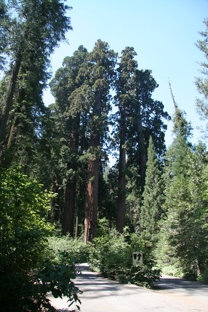
 After getting to Grand Sequoia National Park, I made a stop at some of the major sites along the road such as the old 'Tunnel Rock' under which the old road used to travel before vehicles got too large to clear the roof. One was not be able to help but feel small when driving under the 'Four Generals'. These are giant sequoias that are nearly side-by-side between which the entrance road passes and gave a feel of walking between some large buildings. The next couple of days would often remind of me of scenes from the 'Lord of the Rings' movie. This drive by was likened to the scene in the first movie when the group was floating between the two huge guardian statues. Hospital Rock was neat in that it had several samples of cave paintings that were still visible on the rock while there were also numerous mortar holes (used by natives to crush acorns and such into meal) along several of the large rocks.
  The next stop was one of the visitor's centers to check out the Sentinel Tree. Recall that many of these trees are nearly as tall as the Statue of Liberty and are every bit as majestic as that national symbol. This is supposedly one of the only sequoias that can be photographed in whole with a common consumer camera. As I headed toward Moro Rock, the next climbing spot, for a day hike, I stopped by the sequoia Auto Log and the famous
  tree tunnel that was carved out to allow autos to drive through. The Auto Log fell in 1917 and had part of the 21 diameter trunk chiseled flat upon which cars could be driven and which has been used for multiple car commercials and promotions in the past.
 Moro Rock was a granite dome that was like what I had been on the other day for breakfast, but the views where were even better. There was a trail pretty much carved (by the CCC) into the rock all the way to the summit, however it really didn't mean that it was any less steep of a climb. The pathway for the most part was quite narrow and I passed several people that just didn't have the nerve to go to the top. It can be nervous to slide along a decently precarious ledge with a 400-500 foot drop on the other side of the thin, low rail. The view from the top was, of course, quite nice, but after having to squeeze by a few people, I decided to make my own space and just crossed the rail and sat down for a while. Even in a crowd one can find solitude. When I was looking down from the rail, I could see a plastic chip bag that had been discarded was sitting on a rock outcropping just a few feet down the side. I went to grab it since it was in quite a stable area and had a tiny surprise waiting. I just sometimes karma can do you a favor, because a few inches from the bag was a lens cap with the canon logo on it. remember a few entries back when I said I had lost my lens cap? Well this was a 58mm cap and was exactly what I was missing on my telephoto lens!
The next stop is probably the most visited point in the entire park, the
 'General Sherman Tree'. By volume, this is reported to be the largest tree (or living thing) in the world with an age of ~2300 years, 102' circumference at the base and an estimated weight of 1300 tons. Yeah, it is a big ass tree. Though I'd bet 90% of the people that visit that tree don't explore much further, the 'congress Trail' is a nice 2 mile loop that runs through several nice groupings of sequoias. The National Park Service (NPS) stopped the practice of naming trees a few decades ago, but the old labels are still kept with distinctions such as 'the Senate Group, 'The House Group', and many individual trees named after generals or presidents.
After getting my fill of tourists and pavement, I figured it was time to get out into the world I was there to see.
 I hit the wilderness center to pick up a hiking permit and check my supplies. Unfortunately, the NPS, requires that overnight hikes carry and use a bear-proof food canister. This was 3 pounds of heavy plastic that I did not want to carry, but there really wasn't much choice in the matter, so after renting the necessary equipment and getting the permit, I headed to the trail head parking area. It took a little while to get my pack together and then to clean out the car of everything that had a scent (food, sun block, toiletries, etc) so it could be placed in one of the large bear boxes nearby so that I wouldn't return to a shredded vehicle (hmm, I wonder if insurance covers 'acts of bear'). Being my first hiking trip to bear country, I was a bit nervous, especially after seeing large amounts of droppings the first half-mile of trail. After noticing that there were no human looking parts and seeing that it was mostly hey, I figured that it was from the horses and pack animals that are used for the high Sierra trails. My plan was to start along the Lakes Trail to Panther Gap and then camp about four miles (and 6300 feet gain) in at Mehreten Meadows for the night.
  The trail offered some nice views, but towards the end, I really started to get a bit tired, especially considering I had been driving and already walking and climbing about five miles throughout the day. It started getting dark and though I saw a trail sign, I could not find the meadows. I eventually had to throw up the tent a couple hundred feet of trail since it was getting pretty dark, so after the hammock set up I cooked my dinner and crashed within a minute or so of stretching out.


No comments:
Post a Comment