Well, after 3 weeks on the road, and having visited 6 National Parks, 3 State Parks, 100+ miles hiked, driven 2200+ miles, taken 6000+ photos (though in my weak defense probably 80% were multiple exposure shots and quick actions shots to play with camera features and such), a lose of 8.5 pounds, 0 nights in a hotel, and 1 ice cream cone, I'm back from California.
This was the most amazing trip I have yet to take and was quite the adventure I sought and probably needed. I'll be calling it the 'Summer trip of Superlatives'. I have quite a few blog entries that I'll work on and upload (with pictures of course) over the next few days while I decompress and reset to the humidity, flatness, and such of Florida. I wrote most of the blog entries on the road, but really didn't have time to find a net connection and upload them.
So bare with me for a while if you can. The blogs will probably be pretty wordy, but then again I mostly blog as a personal electronic journal that I can look upon some other time and reminisce. Thanks to the well wishers and folks that thought of me and sent an email or text message. I tried to stay away from the outside world as a means to get away, but the brief periods of sweet electronic luvin were quite nice.
Friday, July 28, 2006
Wednesday, July 26, 2006
Adventure is discomfort and annoyance recollected in the safety of reminiscence.
 Ahhh, after three weeks, it is finally the last day to be in California. Since I didn't have my flight until after 9 o'clock, I still had more time to play/explore. The fog bank was quite thick and did not even let up until well into the afternoon. I spent the morning driving around some of the Golden Gate National Recreational Area on the other side of the bay (wanting to be able to drive over the Golden Gate Bridge once).
  The entire coastline near the bay was spotted with old World War II and even civil war artillery emplacements near Fort Point (that sits under the bridge today) to protect the harbor entrance for attacks that would never come. It was exciting to be able to explore the gun bunkers a bit. Someday I really want to be able to visit the beaches of Normandy where the Allies hit the ground on D-Day. I want to just see what it would have been like covering that ground under such fire. While there were no beaches here, the bunkers overlooking the cliffs would probably have similar views.
  I checked out many of the various unmarked trails and walked along many of the cliff ridge lines that dropped straight into the sea. Because of the fog, the only sounds were nearby birds and crashing waves. Even signs of modern warfare were visible with an old decommissioned NIKE missile defense battery stationed at nearby Fort Barry.
 I had some more time to spend, so I decided to take a tour of the USS Pampanito, a WWII Fleet Submarine. I had been through s WWII era sub several times previously on my visit to Patriot's Point in Charleston SC, but wanted a chance to hear the different stories and see if I'd learn anything new. The sub has been restored and well taken care of by volunteers and even ex-crew members. The submarine force had the highest casualty rate among all the divisions of the armed forces. The taped audio tour had a lot of information and even had many members of the crew recount stories of their patrols. I wish I had more time to take a longer look around and even speak to some of the volunteers, but as may often be the case, time was in short supply.
  I headed out of the Wharf and parked in Chinatown so I could grab lunch and then headed off to the airport. After filling up the tank one final time, I had to spend about 45 minutes cleaning out the car and packing my gear for the ride home. I had to drain the fuel canister so that I could safely discard it as well as clear out all the water bottles, flyers, park maps, and all the other miscellaneous stuff that piled up over the three week period. Return the car was extremely easy and I was heading for the terminal less than 10 minutes after pulling up.
I am so thankful to have had such an amazing experience. Besides the astounding scenery, I met some great people along the way whose kindness and assistance help make this the best trip I have ever had. I cannot imagine going through life and not able to experience the things that make this world such a wondrous place. Too fee seem to take the time to just accept the awe of the natural world and never can understand what they are missing. One does not have to crave adventure to experience these kind of things, but it does add a bit to the overall experience I think. These are the kinds of memories that will last a lifetime. I refuse to tiptoe through life, only to arrive safely at death. I've always wanted my last words/thoughts to be "Wow, what a hell of a ride. I wonder what's next."
Mary had a little lamb, some wine, and a dinner salad.
 It was a decently long drive from northern part of the state, but I made it safely at a decent time to my next destination so I could get some sleep. Every time I mention going to California I am told that I simply must visit Napa Valley. I woke up relatively early and spent a few minutes walking around some of the shops of a nearby outdoor mall where the Chamber of Commerce was located. Though it was about an hour before opening time, one of the employees was coming in early for a meeting and let me in so I could pick up a map and guide book. She was quite pleasant and even spent some time giving out pointers. I took my time heading up the valley and made a bunch of stops along the way to check out the endless fields of grapes. There was a consistent sweet aroma in the air as I walked among some of the trestles with their hanging fruit in various stages of growth. With so many choices, it was hard to determine which of the dozens of wineries I should visit, but I decided to on the Sterling Winery because of the gondola ride it offered (which was a little cheaper with the coupon given to me at the Chamber of Commerce). Though not very long, the self-guided tour was informative to a neophyte like me and educated one on the steps it takes to produce the wine. The tour led though the operations plant where the fermentation process was discussed while the barrel rooms had high stacks of wine that was in the final stages of aging. Included in the tour was of course a series of wine tastings in hope one would be enticed to purchase some bottles.
  I'm not a connoisseur by any stretch of the imagination, but I did enjoy the chance to sample a wide range of products. I finally settled on one of the more sweet dessert wines to bring home. I decided to have a good lunch downtown and was able to pick up an Internet connect and charge my batteries while taking the opportunity to rest for a bit. I would have like to check out some more of the wineries but figure that there really isn't much of a variation among them other than the end product and personalized techniques used in growing and production. Just the valley view and chance to finally learn a bit more about the process first hand was definitely a worthwhile experience.
 My last stop before hitting San Francisco was Mt. Diablo, whose name for some reason was stuck in my head as Mt. Doom, State Park. Though it does not have any waterfalls or population of bears, it does have some features that make it quite unique. It is said that except for Mt. Kilimanjaro, a view from the summit will allow one to see more land than anywhere else in the world. This is owed to the fact that all the land around the base is quite flat without any other mountain ranges nearby to block the view. Apparently the part of the road to the top was under construction and wouldn't be open to traffic until after 5:30, so the ranger suggest I check out a nearby spot called Rock City. This site had several sandstone formations that have eroded over the centuries into various interesting shapes such as Elephant Rock (pictured left). There was a trail nearby that is said to have examples of almost every geologic period visible. Unfortunately it was a bit warm and I just didn't have the energy to do a lot more walking. By the time I finished walking around the area, the access had opened up. It was another few miles of winding road to get to the top, but after getting there I figured that even a long hike would have made the effort worthwhile. Due to the road work and late hour, there was absolutely no one else around. One strange thing that was there was the presence of several dozen dragonflys. I never noticed them elsewhere in the park and it did look weird to have so many flying around, but it was a fun sight to witness. The observation tower was open and provide quite extensive views of the surrounding area.
  If it was not for what I assumed to be a fog bank, I would have guess that I would be able to see San Francisco bay in the far distance. The panoramic pictures do not come out quite so well in the blog, but you can get get a good look on the scrolling film strips below.
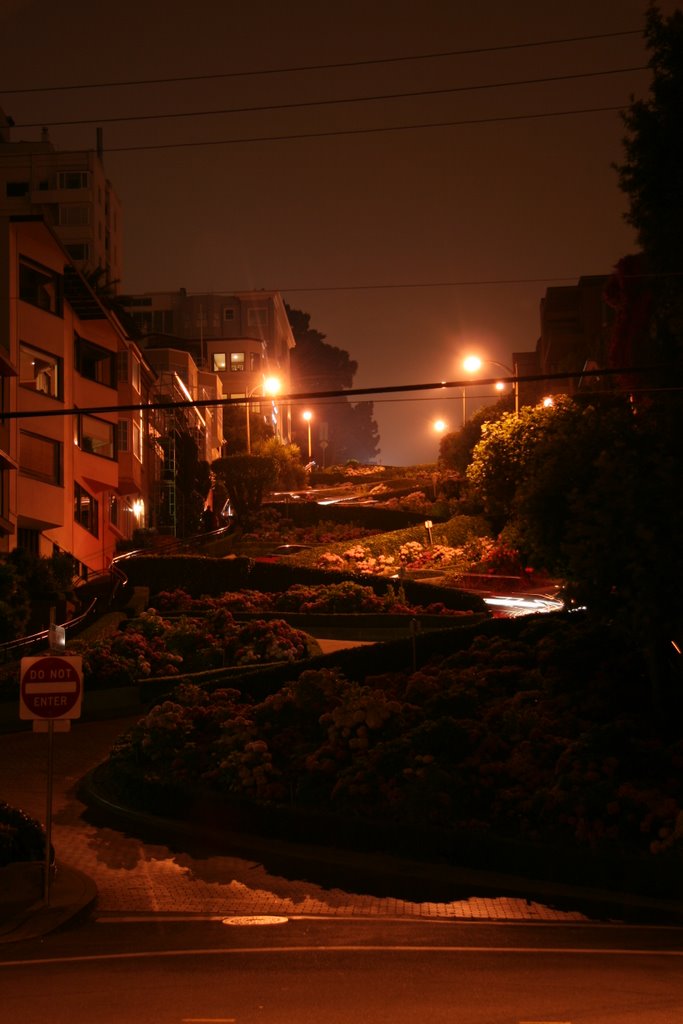 Heading out of the park I made for the final leg of my trip towards San Francisco. I had been here about 5 years ago when visiting a friend, but this was the first time I was able to drive around. I took the Oakland Bridge to the downtown area and parked in the familiar Fisherman's Wharf area. The shops were still quite alive as the evening sun started to set, though I was quite surprised as to how cold it was and would have guessed it to be in the upper 50s. I spent some time walking around the piers and enjoying a but of people watching as the various tourists walked by. As is tradition for me, every adventure has to have ice cream! In celebration for my last night in San Francisco I indulged in a waffle cone of frozen yogart (cannot be too bad at least!) at Ben & Jerry's along the Wharf. I finally drove over to Lombard Street and drove down to the bottom of the most curved street in the world and tried to get a couple of night shots. I then walked around some of the downtown area enjoying the evening ambiance and getting a few architectural shots. If I had more time to hang out, I bet I could have gotten some really neat shots with the time exposure, but I was getting pretty tired so after about 20 minutes I headed to the point near the golden Gate Bridge. There was plenty of parking in the park area, so I got read to bed for the night. As I was about to go to sleep I heard the fog horn sounding in the distance. Since I had not been in an environment where this was common, I grabbed my camera and tripod and walked a mile or so to good vantage point of the bridge. the fog had already gotten so think as to obscure much of the bridge above the roadway.
  The red hazard lights in the distance gave nice eerie glow and made for some great visuals, especially combined with the constant chilly breeze. I finally headed back and felt comfortable sleeping in the near literal shadow of the bridge and close enough to the water to hear it splashing on the seawall rocks.
Tuesday, July 25, 2006
Mountain Climber - A man who always wants to take just one more peak
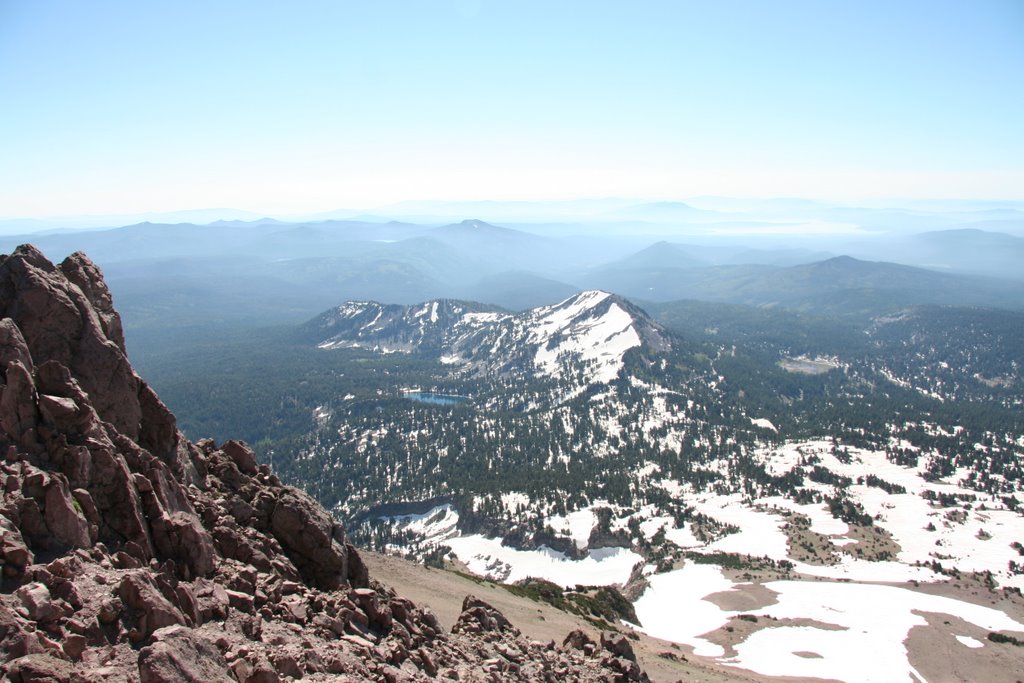
 I wasn't sure if I was going to climb the peak today, but after waking up to such a clear and beautiful, I couldn't resist. Although there was some snow on the lower portions, most of the way up was solid terrain. Mount Lassen is the tallest point in the area and was active with eruptions as early as 1915. The at the top one could still see obvious signs of the crater plugged up and couldn't help but wonder when it might next rumble to life again. There were several informational signs along the way that gave a good description of the geologic history. The summit had a nice 360 degree view, including a clear view of Mt. Shasta about 90 miles away.
  While there weren't any marmots visible, there was a cute chipmunk, probably one of the Rescue Rangers, running around that also seemed apt at finding food. The views were, of course, pretty outstanding and worth the effort. I could feel myself though start to wear down at times and figure I've been putting such a pounding on my body that it was finally going to start complaining.
 After heading back, I drove over to the trail head for the Kings Creek Falls and decided to check it out before leaving the park since it would only be a 3 mile round trip. The meadows were as lush as those in the Yosemite area. Apparently it had been a heavy season of snowfall, which meant that there was a lot of water to saturate the ground to not only provide water for the area flora but keep the
  waterfalls and streams running quite strong. While not quite as tall or wide as the falls in Yosemite, it was still an impressive display of nature and still an excellent hike. I wish I had more time to spend in this national park, however I still wanted to make it to the next destination with plenty of light since I still needed to make it most of the way to San Francisco by night fall. When I started planning the trip I wanted to do more on the west coast, such as the redwood forests and Pacific Coast Highway, however logistics simply were not going to work out this trip. Oh well, I suppose I'll be 'forced' to come back next year.
 After leaving Lassen, I headed over to McArthur-Burney Falls State Park. When scanning the state park book before heading on the trip, I knew I wanted to come here after reviewing the description and seeing a picture on the front cover. Since I have never been to Niagara Falls, these are the most wide that I have yet to experience. About 100 million gallons of water flow over these 128 foot high falls. The parking lot was only about 50 fee from a view of the falls, so it was a different experience to not have to hike several hours to reach the prize, but I was not at all disappointed. I was enthralled with the view of dual falls coming from the top and yet part way down water was pouring straight out of the wall! The falls’ two main cataracts of plunging white water originate from Burney Creek.
  Across the basalt face of the cliff, thousands of rivulets issue through the porous rock from underground aquifers fed by rain and snowmelt, giving the falls a feathery, enchanted appearance. President Roosevelt visited the falls and called them the 'eighth wonder of the world', and it was not difficult to understand why. I took the opportunity to grab a shower while my batteries were recharging and reorganize the car a bit. This was definitely a spot where I could hang out for a while, but about about an hour of sitting by the falls I decided to start heading back. Though the driving to reach Burney Falls and Lassen Peak probably added an extra 500 miles of driving, I think the experience was well worth the time and effort.
Monday, July 24, 2006
There's something strange in the neighborhood. Who ya gonna call?
 I parked just outside the Bodie State Park gates so I could get an early start in the morning before it got too hot and since I had quite a lot of ground to cover later. Bodie is what remains from one of the largest and wildest gold rush towns in California and even had a few residents up until World War II.
 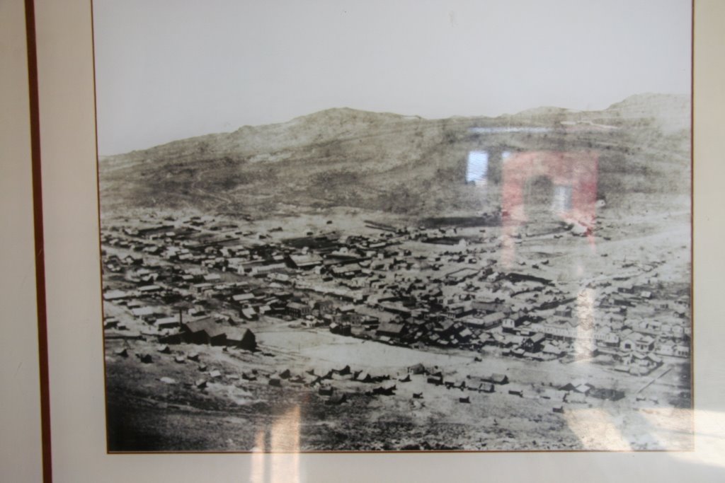 Though only 5% of the town (an old picture can be seen on the right) remains after a massive fire in the 1930's it is still one of the largest remaining examples of life in that time period. As I mentioned once before, I really enjoy walking around such old and abandoned places, so this was a pretty nice treat. There were numerous interper
 active signs around and well as informative talks given by volunteers and rangers that offered a glimpse into the history and lifestyle of those living here. Within 19 years, the are went from a population of 20 to about 10,000 and had about 65 Saloons (talk about a pub crawl!), brothels, and other establishments of ill repute. It was even said that there was one murder here every day, so the undertaker was always in plenty of work!
After checking out the place for a while, I had to head off for northern California since my next planned destination.
 The trip had me going briefly through Reno Nevada, so when I stopped for gas, I of course had to bet (and lose if I might add) a dollar at one of the gaming machines. This area was quite a trek, but I really wanted to check out the still active geothermal bubbling hot spots, mud pots, and mountain streams. Lassen National Park was a beautiful area and though it was a long trek, I am glad I made the journey. There was still a considerable amount of snow on the ground, yet the temperature was quite comfortable. I stopped at several of the overviews and short interperative pathways over the vents and mudpots. While quite vibrant, the area of course had a nasty sulfur smell and was not easy to which you could acclimate. I finally got to the parking area for the Bumpass Hell trail.
  This was a spot in which one of the old time residents lost his leg due to burning when he broke through thin crust into a boiling pool of water when guiding a reporter in the area. Fortunately in the hundred years since the park service has installed boardwalks for people visiting the area. The trail there though was 90% covered, so this was my first real exposure to snow hiking. It took a little getting used to, but the trekking poles were an incredible help. The boiling springs and vents were really neat to watch since all the white and orange-yellowing sulfates (crust) combined with the setting sun provided some great visuals.
  I wanted to hang out for a little while longer but had to follow the retreating sun since I didn't have any supplies with me for the hike. When I return the few cars that had been there were gone and since it was getting dark I just figured I would stay there for the evening since the parking lot for Mt. Lassen was nearby. As I was cooking dinner on one of the nearby ledges, a car pulled into the lot and the occupant took a while setting something up. He had a real nice electronic telescope that was probably as large in diameter as a small car tire. When started up, it looked like one of the automatic guns from the 'Aliens' movie as it tracked across the sky getting a fix for the location. We were far enough from any major city, even Reno and San Francisco, that there was very little real ambient light.
  I was too tired to stay up for long, but just before I crawled into the back of the car to sleep I was able to see more stars than I think I had ever done before. I am not any kind of real astronomer, but I could understand the interest and allure, especially with views such what we were treated to where the night sky was awash with the pinpoints of light that has spent the last million years or so racing across the galaxy.
Sunday, July 23, 2006
Better the devil you know than none at all
 I woke up around dawn so I could get a couple of more shots of early morning lighting of the canyon walls, and even seeing a coyote running around the meadows near Yosemite Falls, and then headed up through Tioga Road towards Tuolumne Meadows to check out some of the amazing scenery that I heard rivals the valley itself. Suffice to say, I was not disappointed in the least when I saw sprawling fields of wildflowers that were miles long and pools of crystal water reflecting a painter's pad of colors from the mountains and skies. I stopped at several of the lakes and meadows areas and always felt that I could stay at each spot for the entire day. Alas, I am pretty limited in time and had to accept the limited exposure.
 After a quick breakfast at the Tuolumne wilderness center, and listening to a lot of the animated stories from the gathered climbers and hikers, I headed my way of of the park towards the next destination. The
  Devil's Postpile National Park that was right next to the famous skiing resort of Mammoth Mountain. In order to get to it, one has to take a shuttle bus because the road simply is not large enough to really carry much traffic. The driver was a wonderful source of knowledge and spent the whole time telling us of the history of the area and stories of the early explorers and protectors. The formations themselves were simply unique hexagonal-shaped balsatic columns that were crafted as the mountain range was being violently born. The columns from the top looked like an old style tile floor with nearly perfect, though weathered, shapes. I then headed towards
  Rainbow Falls. The trail lead through a devastated area that was severely damaged by fire over a decade ago and still bears numerous scars. While the trail itself was a bit eerie, the prize was worth it. Like many names, even if unoriginal, would suggest, Rainbow Falls certainly lived up to expectations. The rainbow colors were quite vibrant with the overhead sunlight and the cool mist made the lack of tree cover considerably more bearable. After cooling off in the natural air conditioning of the basin area, I headed back up the trail to catch the bus back to the main parking area at Mammoth Mountains. I only stopped long enough for a bit of food before heading to Mono Lake State Park.
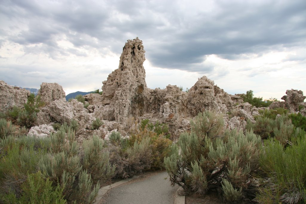 Mono Lake is a quite geologically unique in that it is a salt water lake in the High Sierras and is next to a volcanic crater named Panum that lies just a few miles away. Mono Lake is home to thousands of coastal sea gulls that (about 80% of the state's population each year) fly hundreds of miles to nest and feed in this environment. The lake gets it's salinity content due to the thermal vents that line the lake floor. As water is pushed up, mineral (such as calcium carbonate) deposits pile up into tubular formations. The water is much more dens that even typical seawater making swimming quite a challenge, though I didn't have time to really check it out. I really enjoyed walking through the nature trails that snaked among the formations right up to the shoreline. There were tens of thousands of alkali flies along the trail that covered the ground in a black mass that transformed into a strange visual as one walked through them. I was really impressed with the visuals and sounds at this site and was really glad that I was able to visit.
  After the lake visit I drove over to the crater before it got dark and walked around the rim and dome areas of this dead volcano. The sweeping views of the plains going off into the fence of mountains was almost as alluring as the geologic history of the crater. As I headed out, I made an impromptu stop at an old house on the side of the road that was in the middle of nowhere. This thing did not look like it was inhabited for decades and was to me a little time capsule.
 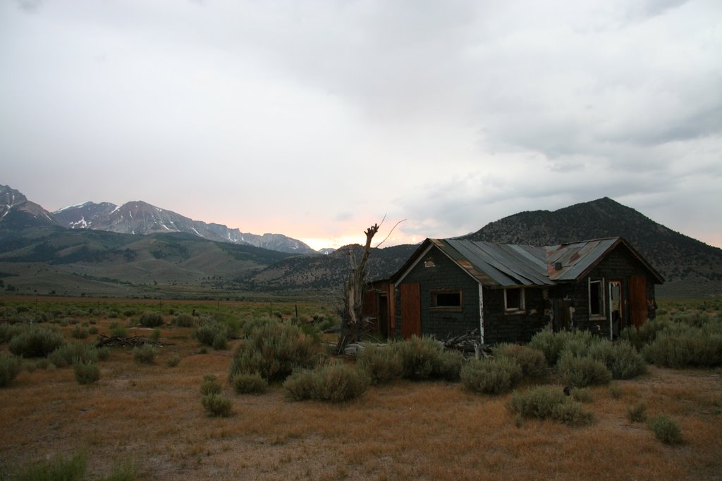 The house was really torn up inside with furniture, appliances, and various items scattered the broken floors and walls. I could not help but wonder who might have lived here and what would have brought them to this site as a residence. After checking out some of the shops of the small town of Lee Vining, I drove close to the state park boundaries of the old ghost town of Bodie.
Saturday, July 22, 2006
If you have a mountain to climb, waiting won't make it any smaller.
 Any search you do on Yosemite NP, you'll get most entries concerning the waterfalls at the valley and Half Dome. For most hikers, Half Dome is *the* day hike to complete in this part as a single trip. It is about 15 miles round trip and involves a constant climb of 4700 feet to the top and the same amount for descent. The last few hundred feet of linear travel involve a very steep descent that is typically only possible by non-climbers because of a series of cables that the park service puts up in the summer months. One usually has to get started at first light in order to comfortably make it back by dusk. When I got to the trail intersection in the morning, about a mile from where I slept, I was only 2 linear miles from the top, but believe me, it was a tough two miles. I cooked some oatmeal and had whatever leftover jerky I had available since I wanted all the energy I could muster. I stashed my pack of everything but my water container, camera, and trail gorp and headed up.
  The trek was pretty strenuous and I could definitely start to feel my body start wearing down after the constant pounding I'd been giving it over the past couple of weeks, but then I really liked getting the chance to really push myself.
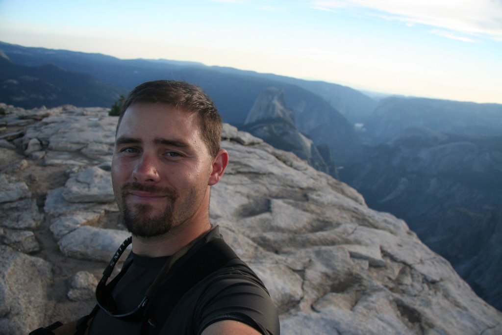
 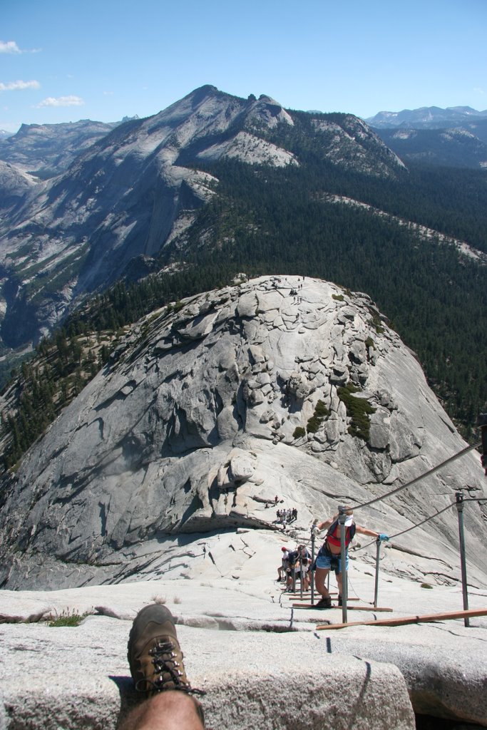 When I got to the cables I rested for a while to finish off my food, set the trekking poles aside, and put on the gloves I brought to protect my hands from the steel cables. Since it was relatively early, there were not too many people yet ascending, so movement was pretty fluid. The pictures I have really cannot easily convey the angle at which we were climbing. The rock was pretty smooth and slipping away from the cables would definitely be the end of you or whomever was below you, so one constantly had to be aware of what was going on ahead of them. Though it took quite a while to finish with a lot of climbing spurts and resting, hitting the summit was exhilarating. I hung out for quite a while taking in the views from all the different angles.
  T
T he only thing that confounded me was how all the marmots got to the top. This was definitely an area of easy pickings for them as I witnessed several incidents of them taking food bags while just a few feet from an unsuspecting picnicker or even chewing through a bag to get to the goodies.
After spending probably two hours up there, I eventually decided to make my way back since I was going to get hungry soon and had no more food available since I did not resupply as I had planned in the beginning. by the time I was ready to go, thee were a good number of people already walking around the top, but as I came down, there was a huge amount of people trying to get up the cables.
 I had to descend on the outside of the cables to really be able to move quickly enough since going down between them would just get too dangerous with a chance of getting entangled with someone. Take a look at the picture to the right to get an idea of the height, steepness, and crowd that was experienced after I made it back down. This base here is about 7 miles from the closest road and on had had an elevation gain of around 4000 feet. If you one can push themselves to do this hike in its entirety, then you can do just about anything.
 The hike back into Yosemite Valley was excellent and I made several long stops a Nevada Falls. I rested for a while along the Silver Apron which was a smooth rocked area that looked like a great water slide, but would turn deadly real fast due to the swiftness of the water before heading to the Vernal Falls via the Mist Trail (having been dubbed the obvious name because of the mist from the rocky basin area).
 After getting back I broke down and decided to hit the pizza place at the Wilderness center to enjoy a calzone and get something to drink that I didn't have to pump through a filter. After a long, but satisfying dinner I figured a shower and clean clothes were in order and went to one of the campgrounds to get cleaned up. Before stopping though, I wanted to get some sunset shots in the valley. Here I saw the most amazing display of colors on the entire trip. Half Dome, Yosemite Falls, and the surround areas were awash in crimson and gold. I could only stare at the wonderous properties of nature and feel so thankful that I had such an opportunity to witness this kind of scene first hand.
  If this is the road to transcendentalism, then I'm interested in learning more. Since I had not done any laundry in quite a while, I spent the last part of the evening in the laundromat and tried to catch up on some of my journal entries while I charged my electronic devices at any of the open outlets I could find.
  After all this was done, I was really too exhausted to drive and went back to the trail parking to sleep in the car, but was accosted by a park ranger around 2AM with the information that car camping was (understandably) not allowed due to bear activity and tendency for people to still keep their food and scented materials with them. Rather than go to a campground and set up a tent, plus pay $20 for 4 hours of sleep, I just gather my materials from the bear box, drove out of the valley, and crashed as soon as was past the posted park boundary.
Friday, July 21, 2006
If being chased by a bear in the woods, you only have to be able to run faster than your friend.
 After waking up I headed over to North Dome for a bit and then headed back up the trail towards
  Snow Creek. After looking at the map for a bit I started to think about redirecting my plan. Since I was already 2500 feet above the valley and planned to climb back up Half dome, I decided that I would approach from another direction. So instead of turning at Snow Creek, I continued up towards Tioga Road. After resting for a little bit, I was able to thumb a ride with a nice older couple that was driving in the same direction since the next trail head was 5 miles down the road. They were a Polish couple that was traveling along the west coast and even happened to have a grandson that was attending USF for engineering. I am always reminded as to how small the world seems to be. As I was heading from the Sunrise Lake are towards Cloud's Rest, I had to make a quick bathroom stop. I left my poles on the trail and walked off to one side to get far enough from the trail.
 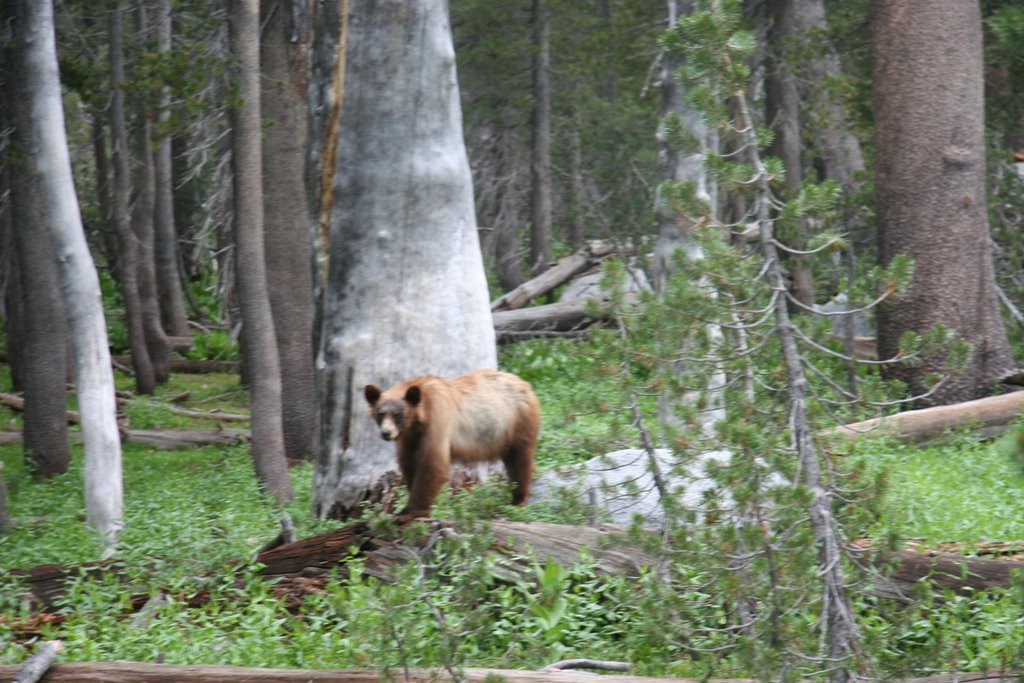 As I was walking back I almost got to the trail when I looked over to the other side and saw, about 30 feet away, a black bear forging around. While it was nice to see the previous bear that was off the road in Sequoia NP several day prior, seeing one completely in a natural environment was a real treat.
 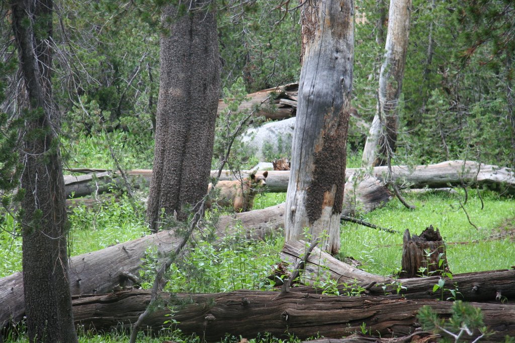 Although I talked to it for a bit, so it knew I was there and not a typical animal, as I retrieved my poles and headed steadily along my way, I really wasn't that nervous. The only times these bears are typically aggressive is when they are protecting their young or territory or when they are used to getting human food and lose their fear. This one was simply forging around and though it kept an eye on my, it didn't seem to be too concerned. I was able to watch it for about 20 minus and get in some decent shots, though wish I had carried the extra weight of the telephoto lens this time. This kind of encounter is just the kind of thing I wanted to witness on this trip and will be memorable for a long time.
 After taking in the experience, I headed back on my way to Cloud's Rest. This was a nice peak and a pretty decent climb, but was well worth the effort since it gave sweeping views of Half Dome and some of the High Sierras in the distance. After hanging out for a while, I headed towards the Half Dome and set up camp about a mile from trail. I had covered about 14 miles of trail (plus the extra 5 mile boost by hitch hiking along Tioga Road) and wanted to get a nice early start in the morning.
Thursday, July 20, 2006
I should have been a poet

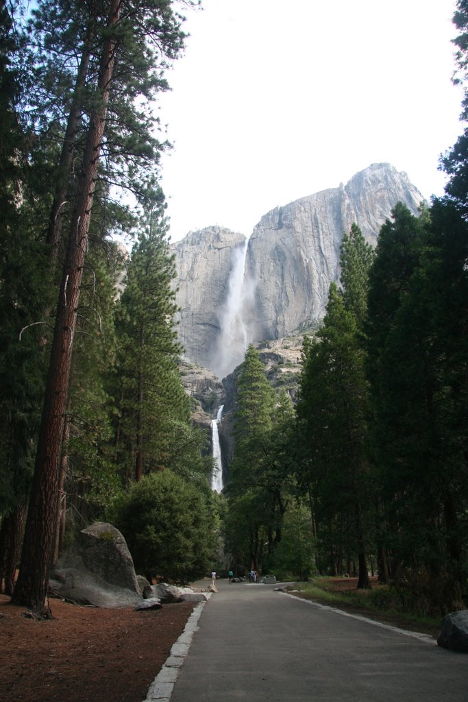
 I wanted to get an early start on Yosemite so I could get some shots of the sunset, so after entering the park around midnight, I drove most of the way to the valley and just parked alongside one of the vistas and set my alarm to get me up a little after dawn. I woke up and drove over to Inspiration Point what is a spot where one has a sweeping view of the valley along with El Capitan, Half Dome, and Bridalveil Falls. To see the sun peaking over the mountains as the light slowly intensified, the colors and clarity were simply amazing. Almost all the visitors and guide books say the same thing in that pictures simply cannot do this area any justice.
  To be in a valley of absolute green with sheer towering walls of stone and to feel the cool breeze as the sun begins the climb is truly breathtaking. I know there will be a lot of pictures in this entry, but I'd suggest clicking on them and seeing a fraction of what even an amateur can capture. After taking in meadow-wide views of Yosemite Falls and El Capitan, I headed over to the visitor's center so I could get a wilderness permit for the next several days of hiking. As in Sequoia, I had to rent and use a bear canister, but after getting the required permits I grab a sandwich at the deli for the trail and went back to the car to organize my gear. It took a while to get everything ready, so I was able to take one of the early shuttles to the trail head.
 I decided to try to make a loop
  out of it and to hike to Upper Yosemite Falls and plan a return trip via Snow Creek/Mirror Lake, resupply, and then head up the Happy Isles Trail towards Half Dome and back. I had intended to hike to El Capitan, but as I climbed and got near the top (it was a very tough climb that took a few hours [left picture]), a thunderstorm came through the valley. After my last lightning experience, I wasn't about to go a lot higher, so I found a rock outcropping in which to hide and set up my sleeping pad and rain gear and curled up for a well needed nap. A couple of hours later the dangerous part and mostly passed so I continued the climb. On the way up, I almost literally ran into a deer that was heading down the trail. It turned around and went back up the trail for a while until it could find a place to scamper out of the way. Reaching the summit of the falls area was quite an achievement and I was able to drop my pack and head to the falls. It was raining still, but I knew I wouldn't want to miss the views from the falls.
 The access to the closest point was extremely precarious. I can now see why a several tourists die each year around the Yosemite Falls. Messing around or a bad slip can be a one way ticket straight down (check out the pictures to the left and right and notice the relationship of the handrails to the edge and valley below). It was like heading up the Stairs of Cirith Ungol towards Shelob's Lair in the last 'Lord of the Rings' movie. Whatever the risk, I think the view and experience is worth it. Because of the rain though, I simply didn't have enough time to make the trek to the top of El Capitain so I just decided to head towards North Dome. Even the areas up here well away from the valley were a beauty to behold, but the rain did put a slight damper on things.
  There were a couple of tents pitched along the way, but since I awoke from my nap, I did not see a single soul for the rest of the day. Finally when it was getting dark I threw up my Hennessy hammock right along the trail, cooked dinner, and set in for the night; finally glad to be able to stretch out inside a warm dry sleeping bag.
Subscribe to:
Posts (Atom)

